
Masonry Vaults in a Historic Monument - Ground penetrating radar - 2 profiles
Description
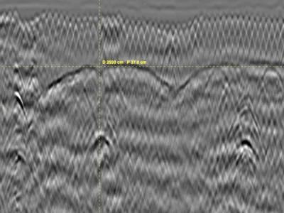
GPR survey inside a historic monument, acquired with a GSSI UtilityScan DF dual-frequency antenna to locate masonry vaults and characterise the structure above them. Two profiles.
Historic masonry is a difficult subject for GPR: unlike reinforced concrete, it has no regular reinforcement to give clear reflections, and the fill above a vault is heterogeneous — rubble, mortar, voids, later alterations. The vault extrados appears as a curved reflection that must be traced among the reflections of the fill itself.
A realistic case for training in non-destructive diagnosis of heritage buildings, where coring and probing are rarely permitted. Raw unprocessed files.
Archive contents
- 5 files
- 13,8 Mo .zip archive
- 23,4 Mo unpacked
-
DZT× 2 numbered 001 à 002 -
DZX× 2 numbered 001 à 002
Also included: GPRbase_LICENCE.txt
Show the full list (5)
001.DZT18,5 Mo001.DZX2 Ko002.DZT4,9 Mo002.DZX2 KoGPRbase_LICENCE.txt6 Ko
Cite this dataset
APA
MDS - Le Matériel de Sondage - GPRbase (2026). Masonry Vaults in a Historic Monument - Ground penetrating radar - 2 profiles [Data set]. GPRbase. GSSI, UtilityScan DF, 300/800 MHz. https://www.gprbase.com/en/dataset/ds025-masonry-vaults-in-a-historic-monument-ground-penetrating/
BibTeX
@misc{gprbase_ds025,
  author       = {MDS - Le Matériel de Sondage - GPRbase},
  title        = {Masonry Vaults in a Historic Monument - Ground penetrating radar - 2 profiles},
  year         = {2026},
  publisher    = {GPRbase},
  howpublished = {\url{https://www.gprbase.com/en/dataset/ds025-masonry-vaults-in-a-historic-monument-ground-penetrating/}},
  note         = {GSSI, UtilityScan DF, 300/800 MHz. Licensed under CC BY-NC-SA 4.0},
}
Discover more archaeology datasets
Free radargrams, editorial guide, and FAQ dedicated to this application.
Explore the category →