
Rib Vault GPR Survey from Above — Backfill Thickness and Structural Geometry
Description
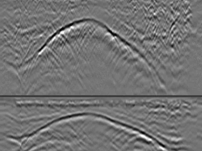
GPR profiles acquired from above a rib vault in a cathedral, with a GSSI UtilityScan DF dual-frequency antenna. Three profiles crossing the vault, recorded from the extrados side to measure the thickness of the backfill covering it. Raw unprocessed files.
The vault reads as a curved reflection whose depth varies continuously along the profile: shallow at the crown, deeper towards the springing. The points where that curve begins and ends mark the extent of the vault — the information a structural survey needs before locating loads, planning an intervention or assessing the fill above.
Cite this dataset
APA
MDS - Le Matériel de Sondage - GPRbase (2026). Rib Vault GPR Survey from Above — Backfill Thickness and Structural Geometry [Data set]. GPRbase. GSSI, UtilityScan DF, 300/800 MHz. https://www.gprbase.com/en/dataset/ds027-rib-vault-gpr-survey-from-above-backfill-thickness-and/
BibTeX
@misc{gprbase_ds027,
  author       = {MDS - Le Matériel de Sondage - GPRbase},
  title        = {Rib Vault GPR Survey from Above — Backfill Thickness and Structural Geometry},
  year         = {2026},
  publisher    = {GPRbase},
  howpublished = {\url{https://www.gprbase.com/en/dataset/ds027-rib-vault-gpr-survey-from-above-backfill-thickness-and/}},
  note         = {GSSI, UtilityScan DF, 300/800 MHz. Licensed under CC BY-NC-SA 4.0},
}
Discover more archaeology datasets
Free radargrams, editorial guide, and FAQ dedicated to this application.
Explore the category →