
← Back to datasets
Detection of a backfilled marl pit beneath a road
Description
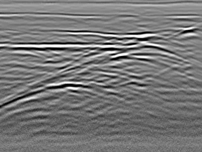
This profile shows a measurement taken at the level of a roadway, with the presence of a marl pit that has been filled in. Several layers of earthwork with different properties are clearly visible, compared to the very homogeneous and attenuating surrounding soil.
sol, remblai, marnière, terrassement, couches
Cite this dataset
APA
MDS - Le Matériel de Sondage - GPRbase (2026). Detection of a backfilled marl pit beneath a road [Data set]. GPRbase. GSSI, UtilityScan DF, 300/800 MHz. Data acquired by MDS Courbevoie. https://www.gprbase.com/en/dataset/ds007-detection-of-a-backfilled-marl-pit-beneath-a-road/
BibTeX
@misc{gprbase_ds007,
  author       = {MDS - Le Matériel de Sondage - GPRbase},
  title        = {Detection of a backfilled marl pit beneath a road},
  year         = {2026},
  publisher    = {GPRbase},
  howpublished = {\url{https://www.gprbase.com/en/dataset/ds007-detection-of-a-backfilled-marl-pit-beneath-a-road/}},
  note         = {GSSI, UtilityScan DF, 300/800 MHz. Data acquired by MDS Courbevoie. Licensed under CC BY-NC-SA 4.0},
}
Discover more geotechnics datasets
Free radargrams, editorial guide, and FAQ dedicated to this application.
Explore the category →