
← Back to datasets
Highway pavement inspection along an emergency stopping lane (ESL)
Description
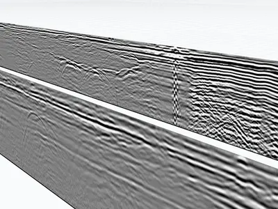
Six dual-frequency ground-penetrating radar (GPR) profiles (300/800 MHz) showing numerous interfaces and pavement structure layers in a soil context highly favorable to GPR. This dataset is very useful for practicing thickness determination (and mapping) in GPRviewer.
Cite this dataset
APA
MDS - Le Matériel de Sondage - GPRbase (2026). Highway pavement inspection along an emergency stopping lane (ESL) [Data set]. GPRbase. GSSI, UtilityScan DF. https://www.gprbase.com/en/dataset/ds010-highway-pavement-inspection-along-an-emergency-stopping/
BibTeX
@misc{gprbase_ds010,
  author       = {MDS - Le Matériel de Sondage - GPRbase},
  title        = {Highway pavement inspection along an emergency stopping lane (ESL)},
  year         = {2026},
  publisher    = {GPRbase},
  howpublished = {\url{https://www.gprbase.com/en/dataset/ds010-highway-pavement-inspection-along-an-emergency-stopping/}},
  note         = {GSSI, UtilityScan DF. Licensed under CC BY-NC-SA 4.0},
}
Discover more geotechnics datasets
Free radargrams, editorial guide, and FAQ dedicated to this application.
Explore the category →