
← Back to datasets
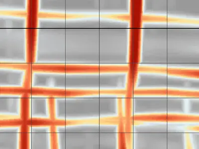
3D concrete scanning over a slab-access ramp interface
Description
60 x 60 cm 3D grid (10 cm spacing). Starting point at bottom left (0,0) and profiles from left to right, then from bottom to top. Try to reconstruct the plan view (C-SCAN or time-slice) from this dataset!
béton, rampe, dalle, renforcement, recouvrement, armatures, aciers, rebar, mesh, concrete, slab
Cite this dataset
APA
MDS - Le Matériel de Sondage - GPRbase (2026). 3D concrete scanning over a slab-access ramp interface [Data set]. GPRbase. GSSI, StructureScan Mini XT/LXT, 2700 MHz. https://www.gprbase.com/en/dataset/ds012-3d-concrete-scanning-over-a-slab-access-ramp-interface/
BibTeX
@misc{gprbase_ds012,
  author       = {MDS - Le Matériel de Sondage - GPRbase},
  title        = {3D concrete scanning over a slab-access ramp interface},
  year         = {2026},
  publisher    = {GPRbase},
  howpublished = {\url{https://www.gprbase.com/en/dataset/ds012-3d-concrete-scanning-over-a-slab-access-ramp-interface/}},
  note         = {GSSI, StructureScan Mini XT/LXT, 2700 MHz. Licensed under CC BY-NC-SA 4.0},
}
Discover more concrete / civil eng. datasets
Free radargrams, editorial guide, and FAQ dedicated to this application.
Explore the category →