
Confirmed Karst Cavities in Limestone — 300 MHz GPR Profiles to 4 m Depth
Description
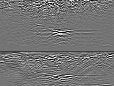
Raw GPR profiles acquired over limestone containing confirmed karst cavities, using a GSSI UtilityScan DF dual-frequency antenna. The 300 MHz channel is the useful one here: it delivers a clear signal down to 3.5–4 m and images the dissolution voids together with the bedrock interface. The simultaneously recorded 800 MHz channel covers the shallow weathered zone and lets you compare both frequencies over the same targets.
This dataset provides an interpretation reference that synthetic or unvalidated data cannot offer. Unprocessed .DZT files, suitable for karst interpretation training, void-detection algorithm testing, and frequency comparison.
Cite this dataset
APA
MDS - Le Matériel de Sondage - GPRbase (2026). Confirmed Karst Cavities in Limestone — 300 MHz GPR Profiles to 4 m Depth [Data set]. GPRbase. GSSI, UtilityScan DF, 300/800 MHz. https://www.gprbase.com/en/dataset/ds018-confirmed-karst-cavities-in-limestone-300-mhz-gpr-profiles/
BibTeX
@misc{gprbase_ds018,
  author       = {MDS - Le Matériel de Sondage - GPRbase},
  title        = {Confirmed Karst Cavities in Limestone — 300 MHz GPR Profiles to 4 m Depth},
  year         = {2026},
  publisher    = {GPRbase},
  howpublished = {\url{https://www.gprbase.com/en/dataset/ds018-confirmed-karst-cavities-in-limestone-300-mhz-gpr-profiles/}},
  note         = {GSSI, UtilityScan DF, 300/800 MHz. Licensed under CC BY-NC-SA 4.0},
}
Discover more geotechnics datasets
Free radargrams, editorial guide, and FAQ dedicated to this application.
Explore the category →