
Georeferenced Multi-Utility Mapping - 30 RTK GPR Profiles at 300/800 MHz
Description
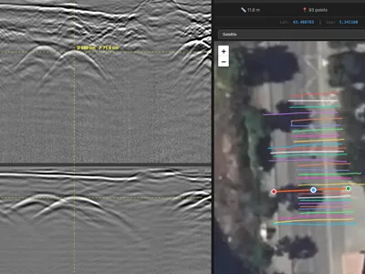
Multi-utility GPR survey acquired for cartographic updating ahead of planned works, with a GSSI UtilityScan DF dual-frequency antenna. 30 profiles, each georeferenced with RTK GPS: raw .DZT radar data, .DZX configuration and .DZG positioning files.
The positioning is what sets this dataset apart. Most freely available GPR data has no coordinates, which limits it to signal interpretation. Here, every trace carries a position, so the detected utilities can be plotted directly, exported to a GIS and compared with record drawings — the full workflow of a mapping campaign, not just a radargram.
Useful for training in georeferenced utility mapping, for testing DZG parsing and coordinate handling in software, and for research on the integration of GPR results into geographic databases. Raw unprocessed files.
Cite this dataset
APA
MDS - Le Matériel de Sondage - GPRbase (2026). Georeferenced Multi-Utility Mapping - 30 RTK GPR Profiles at 300/800 MHz [Data set]. GPRbase. GSSI, UtilityScan DF, 300/800 MHz. https://www.gprbase.com/en/dataset/ds026-georeferenced-multi-utility-mapping-30-rtk-gpr-profiles-at/
BibTeX
@misc{gprbase_ds026,
  author       = {MDS - Le Matériel de Sondage - GPRbase},
  title        = {Georeferenced Multi-Utility Mapping - 30 RTK GPR Profiles at 300/800 MHz},
  year         = {2026},
  publisher    = {GPRbase},
  howpublished = {\url{https://www.gprbase.com/en/dataset/ds026-georeferenced-multi-utility-mapping-30-rtk-gpr-profiles-at/}},
  note         = {GSSI, UtilityScan DF, 300/800 MHz. Licensed under CC BY-NC-SA 4.0},
}
Discover more underground utilities datasets
Free radargrams, editorial guide, and FAQ dedicated to this application.
Explore the category →