
Multiple Utilities and Airwave — Distinguishing Surface Reflections from Buried Targets
Description
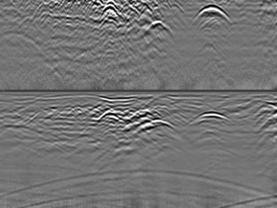
Utility survey acquired with a GSSI UtilityScan DF dual-frequency antenna, showing several buried utilities together with a clear airwave signature.
The airwave is what makes this dataset worth studying. Part of the emitted energy travels through the air rather than the ground, reflects off objects above the surface and returns as a hyperbola that looks like a buried target. Its velocity gives it away: propagation in air is faster than in most soils, so an airwave hyperbola is markedly wider and flatter than a true subsurface reflection at the same apparent depth.
Mistaking one for the other leads to phantom utilities on a plan. Having both on the same profile makes the comparison direct. Raw unprocessed files.
Cite this dataset
APA
MDS - Le Matériel de Sondage - GPRbase (2026). Multiple Utilities and Airwave — Distinguishing Surface Reflections from Buried Targets [Data set]. GPRbase. GSSI, UtilityScan DF, 300/800 MHz. https://www.gprbase.com/en/dataset/ds028-multiple-utilities-and-airwave-distinguishing-surface/
BibTeX
@misc{gprbase_ds028,
  author       = {MDS - Le Matériel de Sondage - GPRbase},
  title        = {Multiple Utilities and Airwave — Distinguishing Surface Reflections from Buried Targets},
  year         = {2026},
  publisher    = {GPRbase},
  howpublished = {\url{https://www.gprbase.com/en/dataset/ds028-multiple-utilities-and-airwave-distinguishing-surface/}},
  note         = {GSSI, UtilityScan DF, 300/800 MHz. Licensed under CC BY-NC-SA 4.0},
}
Discover more underground utilities datasets
Free radargrams, editorial guide, and FAQ dedicated to this application.
Explore the category →