
Free Compass NX (.nx) Files — Dual-Frequency GPR Data
Download real .nx files from the GSSI Compass NX, 400 MHz and 1 GHz, for ground investigation and underground utility detection
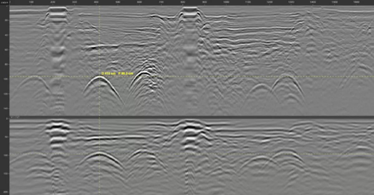
The .nx format is the native data format of the Compass NX, the dual-frequency ground radar from GSSI (Geophysical Survey Systems, Inc.). Its antenna records two channels at once, 400 MHz and 1 GHz, along the same profile: the low frequency for depth, the high frequency for detail in the top few decimetres.
GPRbase provides free .nx sample files from real underground utility detection and ground investigation surveys. They are raw data, exactly as recorded by the instrument, distributed under Creative Commons BY-NC-SA 4.0 for education, research, software development and testing.
Whether you are evaluating the Compass NX before buying or renting, training operators to read utility radargrams, or comparing how both frequencies respond on the same ground, these files give you real-world signal complexity that synthetic data cannot provide.
Free Compass NX sample files
Each dataset below contains raw .nx files — download and explore — 1 datasets available
What is an .nx file?
An .nx file is produced by the NX Control app, which drives the Compass NX from a tablet or smartphone. It holds one profile and brings together both channels recorded simultaneously, the acquisition parameters and, when a GPS is used, the positions recorded during the measurement.
This is the main difference from the DZT format of other GSSI systems: there is no separate positions file to keep alongside the radar data. GPRbase archives deliver the .nx files under their original names.
How to open an .nx file?
GPRviewer, published by MDS, opens .nx files, in the free version as well as with the PRO subscription. Geolitix also supports them for online 2D and 3D processing and interpretation. Open-source libraries designed for DZT, such as readgssi, GPRPy or RGPR, do not read the .nx format.
The Compass NX: two frequencies in a single pass
The Compass NX combines a cart with a two-channel stepped-frequency (SFCW) antenna: 400 MHz low frequency and 1 GHz high frequency. Both channels are acquired at the same time, which avoids a second pass with another antenna and lets you compare resolution and depth directly on the same profile.
Acquisition runs continuously or by survey wheel, at 50 traces per metre. According to the datasheet, investigation depth can reach 6.7 m at high frequency and 13.4 m at low frequency under ideal ground conditions; it varies widely with soil type, water content and conductivity.
Applications: underground utilities and ground investigation
The Compass NX is dedicated to underground utility detection and ground investigation: locating pipes, cables and ducts, identifying layers and fill, spotting anomalies before works. The 1 GHz channel brings out objects close to the surface, while the 400 MHz channel follows deeper utilities and subsurface structures.
Compass NX datasets on GPRbase are filed under the matching applications and list the targets surveyed.
GPS positioning
The Compass NX can record its position from the internal GPS of the mobile device that drives it, or from an external receiver connected to the antenna. Accuracy depends on the receiver used. The positions are then stored inside the .nx file itself. On each GPRbase dataset page, the “GPS files” line shows whether the dataset is georeferenced.
Download free Compass NX sample data
The datasets below contain raw .nx files, free to download under CC BY-NC-SA 4.0. Use them to discover the Compass NX, build teaching material on utility detection, or compare how both frequencies respond. Each dataset documents the antenna, frequencies and targets.
Frequently asked questions — Compass NX files
Which software opens .nx files?
GPRviewer, published by MDS, in its free or PRO version, and Geolitix for 2D and 3D processing. Open-source libraries built for DZT do not read this format.
What is the difference between an .nx file and a .DZT file?
Both are native GSSI formats. DZT, used by most systems, may come with a .DZG for GPS positions and a .DZX for configuration. The .nx, specific to the Compass NX, holds both channels and, when recorded, the positioning in a single file.
Are these .nx files raw or processed?
They are raw, exactly as recorded in the field by NX Control. No filtering, gain or migration has been applied.
Why two frequencies?
Frequency sets the trade-off between resolution and depth. 1 GHz resolves small objects close to the surface; 400 MHz penetrates deeper, with less detail. Recording both together covers both needs in a single pass.
Can I use these files to test my own GPR software?
Yes. CC BY-NC-SA 4.0 permits software testing and development use, excluding direct commercial use. Real files acquired on different sites are ideal validation material.
Need to view these .nx files?
GPRviewer, published by MDS, opens Compass NX files. Adjust gain and filters, measure depths — the free version is enough to get started.
Discover GPRviewer