
Free GPR Datasets for Geosciences
Real-world radargrams for subsurface mapping, permafrost investigation, glacier studies and sediment analysis
Geoscience research leverages Ground Penetrating Radar for a wide range of Earth science investigations: sediment stratigraphy, permafrost monitoring, glacier internal structure, hydrogeology, natural hazard assessment, and paleoseismology. GPR provides high-resolution subsurface imaging that traditional geological methods cannot achieve at this scale of detail and speed, making it a cornerstone of modern near-surface geophysics.
GPRbase provides free geoscience GPR datasets from a variety of natural settings: fluvial deposits, coastal environments, arctic terrains, alpine glaciers, and karst systems. Each dataset contains raw radargrams in GSSI format (.DZT), documented with the geological context when available. Data is distributed under Creative Commons BY-NC-SA 4.0 for academic research, education, and open science initiatives.
These datasets support graduate research in Earth sciences, coursework in geophysics and sedimentology, algorithm development for automated stratigraphic interpretation, and the growing field of environmental GPR applications. The datasets capture natural subsurface complexity — heterogeneity, moisture variability, cross-cutting features — that synthetic data cannot replicate.
Geoscience GPR datasets
Free raw radargrams — download and explore — 3 datasets available
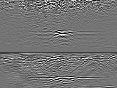
Confirmed Karst Cavities in Limestone — 300 MHz GPR Profiles to 4 m Depth
Raw GPR profiles acquired over limestone containing confirmed karst cavities, using a GSSI UtilityScan DF dual-frequency antenna. The 300 MH…
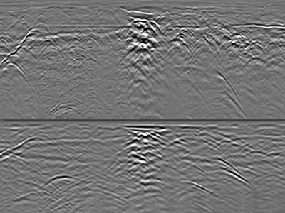
Utilities & Interfaces in Favorable Soil with Deep GPR Penetration
GPR dataset containing 1 file collected with a GSSI UtilityScan DF dual-frequency 300/800 MHz ground penetrating radar in highly favorable s…
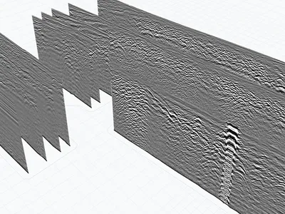
Georeferenced dual-frequency ground-penetrating radar (GPR RTK) files
16 Radar profiles in a parking lot, showing heterogeneous soil conditions. The data is georeferenced and can be imported into GPRviewer for …
GPR for geoscience research
GPR provides high-resolution subsurface imaging that complements seismic, resistivity, and drilling methods used in Earth sciences. Its ability to image at meter-to-decimeter resolution in the top tens of meters makes it ideal for near-surface investigations where other geophysical methods lack precision. Widely adopted in hydrogeology, sedimentology, cryosphere science, and environmental geosciences.
Sediment and stratigraphy imaging
GPR reveals bedding, cross-stratification, channel geometries, and depositional structures in fluvial, coastal, and glacial settings. It captures internal sedimentary architecture non-invasively over hundreds of meters — an ideal complement to trench exposures and cores. Widely used to reconstruct paleoenvironments and constrain sedimentary models.
Permafrost and cryosphere applications
In cold regions, GPR maps active layer thickness, ground ice distribution, and permafrost boundaries. Ground ice creates distinctive strong reflections at material interfaces, making GPR essential for permafrost monitoring in the context of climate change research. Frozen ground can dramatically improve GPR performance, enabling deep investigations.
Glaciers and ice sheets
GPR reveals internal glacier structure: englacial layers, water bodies, crevasses, and the bedrock topography beneath ice. Airborne and ground-based GPR surveys have transformed glaciology, providing detailed thickness measurements and internal architecture. Critical for glacier mass balance studies and long-term monitoring.
GPR frequencies for geoscience
The 50-500 MHz range covers most geoscience applications. Low frequencies (50-100 MHz) enable deep investigations — glaciers, deep aquifers, thick sedimentary sequences. Mid-range frequencies (200 MHz) balance depth and resolution for most stratigraphic work. Higher frequencies (400-500 MHz) provide detailed shallow investigations for near-surface processes.
What these datasets let you practise
Geoscience datasets have in common that they cover natural ground rather than structures, with the propagation contrasts that implies. One profile recorded in particularly favourable soil reaches substantial penetration depth and reveals numerous interfaces, layers and material changes — well suited to interface picking and stratigraphic analysis.
Georeferenced profiles over heterogeneous soils complete the set, along with confirmed karst cavities in limestone, where comparing 300 and 800 MHz over known targets illustrates the trade-off between resolution and penetration.
Which software opens these files · Select these datasets programmatically
Download raw geoscience GPR data
All datasets are raw radargrams in .DZT format, without pre-processing or interpretation overlay. This makes them ideal for realistic research, teaching examples in geophysics and sedimentology courses, algorithm development, and reproducibility studies. Free download, immediate access, no account required.
Frequently asked questions — Geoscience GPR
Can I use these datasets in a peer-reviewed publication?
Yes, with proper attribution as required by CC BY-NC-SA 4.0. Cite the dataset identifier and GPRbase URL. The license permits research use, including publications, provided derivatives are shared under the same terms.
Are datasets from cold regions and permafrost available?
When contributed. The metadata specifies the acquisition environment, allowing researchers to filter by relevant conditions. Contributions from arctic and alpine environments are especially welcome.
Can I use GPR datasets to test seismic interpretation algorithms?
Partly. GPR and seismic have similar data structure (2D or 3D wavefield reflections) but different underlying physics. Best used for teaching interpretation principles and testing generic feature detection algorithms rather than physics-specific inversions.
Are these datasets calibrated with ground truth?
Some are; documentation is provided when available in the dataset description. When boreholes, trenches, or physical measurements are available, they are noted in the metadata.
How should I cite these datasets in research?
Use the dataset identifier (dsXXX) and the GPRbase URL. A recommended citation format including contributor attribution is available on the license page. This helps track dataset usage and encourages further contributions.
Have geoscience GPR data to share?
Contributions from researchers, academics, and geoscience professionals enrich the community. Every dataset submitted advances open science in Earth sciences.
Submit your data