
Free Archaeological GPR Datasets
Real-world radargrams for non-invasive prospection of walls, tombs, foundations and buried structures
Archaeological GPR surveys have transformed how researchers investigate historical sites. Non-invasive, non-destructive, and covering large areas quickly, GPR reveals buried walls, foundations, tombs, and structures without disturbing the archaeological context. It complements traditional excavation by guiding where — and how — to dig, maximizing scientific yield while preserving heritage.
GPRbase provides free archaeological GPR datasets acquired on real historical sites: ancient settlements, cemeteries, medieval structures, and rural sites of interest. Each dataset contains raw radargrams in GSSI format (.DZT), documented with the archaeological context when the contributor permits. Data is distributed under Creative Commons BY-NC-SA 4.0 for research, education, heritage preservation, and open science.
These datasets support archaeology and heritage program training, methodological research on GPR interpretation of anthropogenic features, algorithm development for automated feature detection in complex archaeological contexts, and case study libraries for university courses. The real-world variability of archaeological sites — soil moisture, superimposed historical phases, natural noise — is captured authentically.
Archaeological GPR datasets
Free raw radargrams — download and explore — 2 datasets available
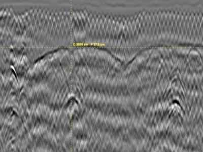
Masonry Vaults in a Historic Monument - Ground penetrating radar - 2 profiles
GPR survey inside a historic monument, acquired with a GSSI UtilityScan DF dual-frequency antenna to locate masonry vaults and characterise …
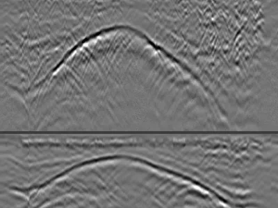
Rib Vault GPR Survey from Above — Backfill Thickness and Structural Geometry
GPR profiles acquired from above a rib vault in a cathedral, with a GSSI UtilityScan DF dual-frequency antenna. Three profiles crossing the …
GPR for archaeology
GPR is non-invasive, protecting the archaeological context and cultural heritage. It reveals structures without excavation, allowing researchers to plan targeted digs, design efficient research strategies, and identify features that might otherwise be missed. Its ability to cover large areas quickly makes it invaluable for site evaluation and rescue archaeology campaigns.
Wall and foundation detection
Buried masonry, stone walls, and building foundations produce clear planar reflections and hyperbolic signatures on GPR data. The contrast between constructed materials (stone, brick, mortar) and surrounding soil creates distinctive radar responses. Wall alignments, room layouts, and complete building footprints can be mapped without excavation, providing invaluable planning information.
Tomb and burial detection
Cavities from tomb chambers and disturbed soil zones from burials produce distinctive radar anomalies. GPR helps map cemetery layouts, identify unmarked graves, and locate tomb chambers before targeted investigation. In forensic and humanitarian contexts, GPR is also used to locate clandestine burial sites.
Extended structure mapping
Dense GPR surveys — parallel lines spaced 25-50 cm apart — produce 3D data cubes that can be sliced horizontally to reveal plan-view maps of buried structures. These time slices show the spatial pattern of walls, streets, and building complexes at different depths, transforming archaeological research design and site interpretation.
GPR frequencies for archaeology
The 200-500 MHz range is most common for archaeological surveys. For shallow finds (0.5-3 m depth), 400-500 MHz provides an ideal balance of resolution and penetration. For deeper structures such as classical foundations or deep burials, 200-270 MHz antennas trade resolution for better penetration. The trade-off must be matched to expected site depth.
What these datasets let you practise
Historic fabric poses a different problem from reinforced concrete: masonry has no regular reinforcement to give clean reflections, and the fill above a vault is heterogeneous — rubble, mortar, voids, later alterations. Two datasets address this. The first shows masonry vaults in a historic monument, where the extrados has to be traced among the reflections of the fill itself.
The second was acquired from above a rib vault, to measure the thickness of the backfill covering it. The vault reads as a curved reflection whose depth varies continuously: shallow at the crown, deeper towards the springing. The points where that curve begins and ends mark the extent of the vault — the information a structural survey needs before any intervention. This configuration is not available anywhere else in open data.
Which software opens these files · Select these datasets programmatically
Download raw archaeological GPR data
All datasets are raw radargrams in .DZT format, without pre-processing or interpretation overlay. This makes them ideal for realistic study of archaeological signatures, methodological training, algorithm development for automated feature detection, and university teaching. Free download, immediate access, no account required.
In preparation
The following datasets are being prepared for this application.
- Buried stone wall, Gallo-Roman remains autumn 2026
Do you hold an acquisition of this kind? We would be glad to publish it, with credit to the contributor.
Frequently asked questions — Archaeological GPR
Can GPR replace archaeological excavation?
No — it guides excavation. Excavation remains essential for interpretation, dating, and physical study of artifacts. GPR indicates where to dig and what to expect, making excavation more efficient and less destructive.
What soil conditions favor archaeological GPR?
Sandy, dry, low-clay soils give the best results. Wet clay strongly attenuates GPR signals and can limit useful depth to less than a meter. Frozen ground can improve performance dramatically.
Are these datasets from protected heritage sites?
Site location is anonymized when heritage protection requires. Metadata provides sufficient context (soil type, target depth, archaeological period) without compromising site security.
Can students use these datasets for coursework?
Yes, CC BY-NC-SA 4.0 permits educational use with attribution to GPRbase. Datasets are excellent teaching material for archaeology, heritage, and geophysics programs.
What's the difference between 2D profiles and 3D grids?
2D profiles are single acquisition lines showing a subsurface cross-section. 3D grids are dense parallel lines processed into a data volume that can be sliced horizontally to reveal plan-view maps of buried structures at different depths.
Have archaeological GPR data to share?
Contributions from archaeologists, heritage organizations, and researchers enrich the community. Every dataset submitted advances non-invasive heritage investigation.
Submit your data